YOUR RESEARCH, YOUR ARCHIVES
Map Collection
Arranged chronologically, the map collection documents the development of DeKalb County over the past two centuries. The collection includes 1924 (with overlays from the 1930s-1960s) Sanborn Maps (books) of Atlanta and the 1928 topographical maps of Atlanta, as well as some local area maps. See Reference & Periodicals for plat maps selection.
Very few of our maps have been digitized due to their large size. Researchers must come to the archives to view maps in person. Please “Contact the Archives” to let us know what area(s) you’re interested in, we’ll check our map files, and get back to you.
Unless otherwise noted, the images in our collections belong to the DHC, a membership based non-profit, and may only be reproduced with our written permission. If permission is granted, you will be charged a fee and we will need information including, but not limited to, the intended use, publisher, and date of publication. Please contact the archivist for additional information about using images from our collection.
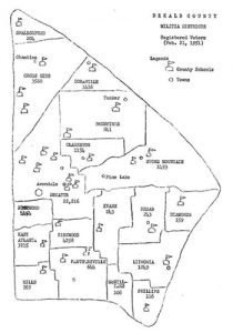
Here are some of our maps:


Militia Districts Key, older numbers
District Number / Name
524: Shallowford
686: Cross Keys
1416: Doraville
572: Browning
1327: Clarkston
1045: Stone Mountain
531: Decatur
1379: Edgewood
1586: Kirkwood
637: Evans
1398: Redan
563: Diamonds
1342: Hills
536: Panthersville
1448: McWilliams
683: Lithonia
487: Phillips
Militia Districts map, 1951 numbers
In 2023, DHC applied for and subsequently won a grant from The Digital Library of Georgia and the University of Georgia to digitize 10 plat map books from the early 20th century. We’ve included the link here to the DLG site so that you can search the maps.


